Historical Basemaps
Since the purpose of MormonPlaces is to help people better understand the historical geography of the Church, it only makes sense to put that in the context of historical geography in general. For example, the rapid multiplication of wards in the Sugar House area south of Salt Lake in the early 20th Century makes a lot more sense when you realize that this was an area of rapid suburban development at the time. To that end, we are working on some historical basemaps that can be shown under the MP data.
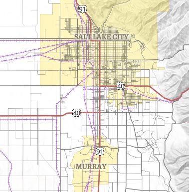
1930 Road Map
 This
map shows the roads and cities of Utah as they existed in 1930, at the end of the
period that MormonPlaces portrays. Brandon and his students have
collected this information from a variety of sources, including maps
and early air photographs. We decided to limit it to Utah, where
cities had multiple wards, which make the streets very relevant. For
this reason, we could extend it to southeastern Idaho and Los Angeles,
but it is a lot of work. Even the Utah map is not yet complete. For
example, we have not been able to find 1930 boundaries for many cities
that we know were incorporated at the time.
This service can be especially helpful for looking up old street names. The current gridded "100s" addressing system, ubiquitous in Utah today, was first implemented in the 1940s, and was not fully standardized in Salt Lake City until 1972. Before that, most cities had a similar ordinal numbering system (1st W, 2nd W, 3rd W), but some were very different, which can make genealogical research difficult. For example, until 1972, the northern and western streets in Salt Lake City started numbering after North Temple and West Temple, not South Temple and Main Street as today, so all of the numbers are one off, which can frequently lead to confusion when doing research in this area. In the early years, many cities even had named streets or other variations, which are also shown here.
Just for fun, we bundled it with a 1900ish base map of the United Kingdom, provided by the National Library of Scotland using old Ordnance Survey maps. It is especially helpful for finding many of the early branches of the British Mission that were in rather small villages. We've also added a similar era topo map service of Denmark, which is especially useful for the 19th Century, when there were a lot of branches there.
If you have any maps or other sources that will help us improve this dataset, feel free to contact me at plewe@byu.edu.
Early Roads
This base map will include roads as they existed in various areas at various times, focusing on areas where members of the Church were gathered. The date is not consistent across all areas, but is meant to reflect what it looked like when the Saints lived there and when we can find data:
- Independence, Missouri in 1834
- Kirtland, Ohio in 1836
- Nauvoo, Illinois in 1845
- The Winter Quarters/Kanesville Area in 1851
- The Wasatch Front in 1856
